Links
Summary
This four-mile circular walk starts in Brockholes, in the middle of the Holme Valley between Honley and New Mill. It heads over the River Holme, up to the attractive village of Netherthong, and back again. There are several milestones, other waymarkers and interesting road history features on the walk, as well as some splendid views. About half is on roads and the rest on well-marked tracks and paths, some of which can be muddy at times. It is suggested that you take Ordnance Survey Explorer (1:25,000) map 288 – Bradford and Huddersfield – with you. [NB: the map below is taken from the 1955 edition so is to be used with care.]
To get to the starting-point
By bus: From Huddersfield Bus Station First buses 314 (to Holmfirth and Holme) and 316 (to Holmfirth: Parkhead) pass through Brockholes, approximately every 30 minutes. Get off just after the Post Office, very close to the boundary stone, the first item of interest on the walk.
By car: Brockholes is on the A616, 4½ miles south of Huddersfield, 17 miles from the M1 junction 35A. Turn off the A616 where a sign points up to the station; there is safe on-street parking on this road, around the Methodist Church (sat-nav HD9 7AR).
By train: Brockholes is served by a station on the Huddersfield to Sheffield line. Trains run hourly during the week, and two-hourly on Sundays. On leaving the station turn left and then right to walk down the hill to the Methodist Church on the left (about 200 yards).
Map
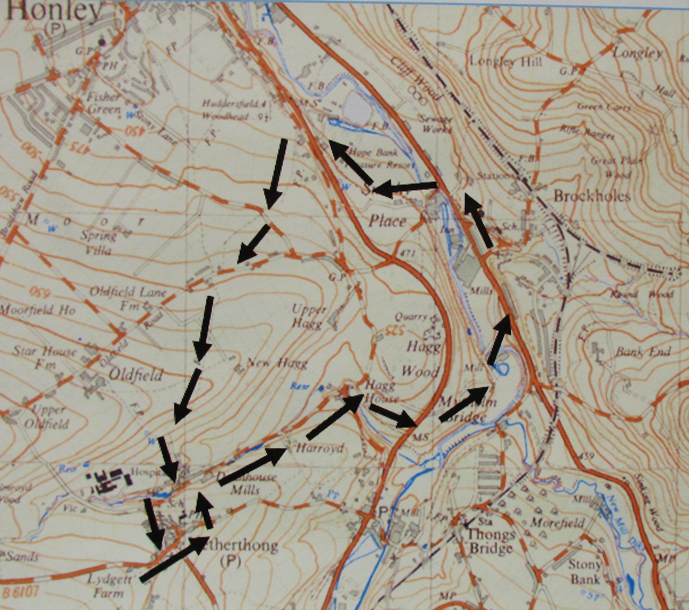
The walk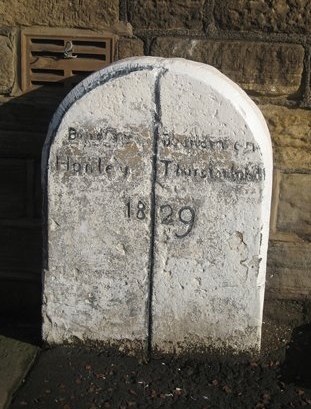
From the Methodist Church walk down the road to the A616 and turn right. Outside no 345 notice a boundary stone, marking the boundary between the townships of Thurstonland and Honley, dated 1829.
Although the township of Thurstonland is up on a hill east of Brockholes its boundaries ran down to the River Holme until 1937 when an enlarged Holmfirth Urban District was created. The stone is, sadly, even less legible now than it was in the photograph alongside. It reads Boundry Honley and Boundry Thurstonland, with the date 1829. This was shortly after the road was constructed: it was possibly erected because of a dispute between the Turnpik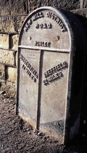 e Trust and Honley township.
Carry on past the Post Office, cross Brockholes Lane, and then cross the main road at the pedestrian crossing. At the end of the building on this side of the road you will notice a milestone.
This milestone is one of over 600 set up by the West Riding County Council in 1893/4, shortly after it was established and took over responsibility for major highways in the county. The plates of these milestones were made by the firm of Brayshaw & Booth, ironfounders of Liversedge, whose name can be read on the panel. Most of them were triangular, but this one is flat; it was thought that flat ones were erected because the road was originally narrower, but there is no evidence that this was the case here. You can read all about Brayshaw & Booth milestones on our website, www.yorkshire-milestones.co.uk – follow the links from “All about milestones” on the home page. All the “B&B” stones have standard wording: the name of the former turnpike trust; the township name; and the mileages to each destination (and sometimes intermediate destinations).
Here therefore the Trust name refers to the New Mill District branch, or extension, of the 1805 Wadsley and Langsett turnpike: it connected Honley (and therefore Huddersfield) with the Flouch Inn near Langsett (and therefore Sheffield) - hence the distances, Huddersfield (4½ miles) and Sheffield (22 miles). [At the Flouch, originally built in 1827, presumably to take advantage of the increasing passing traffic, the road crossed what was originally an old saltway from Cheshire, later turnpiked between Stockport and Barnsley, now the A628]. 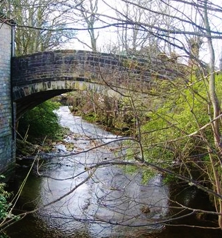
Continue over Smithy Place Lane, noticing the old pack-horse bridge, now closed to traffic, and a replica of a toll-bar charges board.
The bridge at Smithy Place was an important crossing-point of the river, and tracks from Honley, Oldfield, Thurstonland and elsewhere converged here in pre-turnpike days. Smithies, like inns, were often established on old well-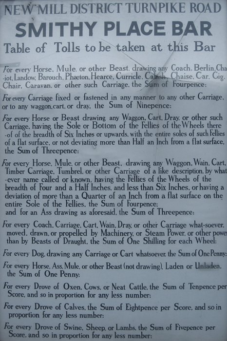 used tracks. When the turnpike was constructed, in 1825, there were a number of toll-houses, including one at Smithy Place, each displaying the charges due from all passing people, animals, carts and other forms of transport. Like many others, because they often stuck out into the road, this one has not survived.
Turn left to cross the old bridge and carry on up the road. Soon, just past no 21, a public footpath sign points right, up some stone steps, and onto a lane.
Notice a house called Moisy Cottage. This track is now call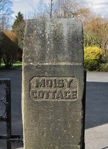 ed Robinson Lane, named after the family who owned the nearby Smithy Place Dyeworks. It was formerly known as Moisy Lane: the origin of this is obscure, but possibly a regional term related to mossy.
Follow this to a point just beyond the last house (Wheatfield House), where the lane veers left, and a track is visible to the right through a field. Take this track; the field may be boggy as you approach the cottage on the right.
To the right is Hope Bank Works, currently occupied as workshops and community arts spaces, but previously the site of popular pleasure gardens, with two boating lakes – opened in 1895 and closed in 1955.
The path then goes by the side of a wall (on the right) before reaching another main road.
This is the former Huddersfield to Woodhead Turnpike (now the A6024),which leads from Huddersfield through Holmfirth, over Holme Moss and into what was Cheshire until 1974 (now Derbyshire). It joins the A628 Stockport to Barnsley road at Woodhead. [Woodhead is a sparsely-populated chapelry in Mottram-in-Longendale parish: the original chapel was built many centuries ago for the spiritual benefit of travellers in this desolate spot. The graveyard of the present 18th century church contains the unmarked graves of the navvies who died during the construction of the (now closed) railway]. This section of the road is actually the “new turnpike” of 1831 which took a route from a new Honley Bridge (which has the date 1828) along the valley bottom through Hagg Wood towards Holmfirth.
Continue in the same direction, staying on this side of the road (the pavement resumes after the works entrance. It is a short distance to a road forking up to the left.
At this point you will notice a very worn and now sadly illegible milestone, marking 4 miles from Huddersfield and 9½ to Woodhead. (Unt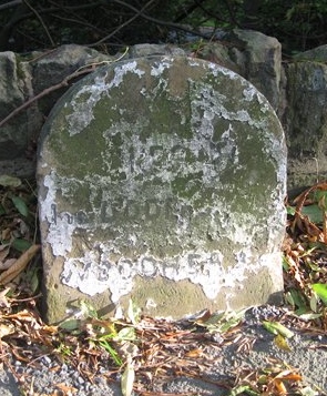 il quite recently the words Huddersfield and Woodhead were just discernible, but bits have broken off since. Nevertheless, the stone is listed by English Heritage.) This road, the new turnpike, has a series of the original milestones, which continue from this one up to Holme Moss. For some unknown reason they were never replaced by the “Brayshaw & Booths” of the County Council.
Now carefully cross the main road and walk up the (unnamed) road opposite. At the top you will find yourself on Far End Lane. Turn sharp left onto this road.
You are now on the original turnpike road – in fact nearer Honley it is called “Old Turnpike”. Constructed in 1768, it followed the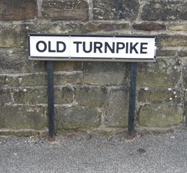 top side of Hagg Wood to Thongsbridge.
Continue as far as a public footpath sign pointing right, and a street sign leading to Far Banks nos 56 A, B and C. Follow this, up the hill; after the last house, carry on up the track, with an over-large laurel hedge on your left, over a stile and into a field. Keep the wall on your right.
Reaching a road, Long Lane – there is a bench here – cross over, and slightly to your left the footpath continues, still in the same direction (roughly south-westerly), gently uphill, with the wall on your left. At the top of this first field continue over two stone stiles; now the wall is on your right. In the next field head diagonally towards a gate to the left of a house, and you will reach Oldfield Road. Turn right. Have a look round to admire the view, if you haven’t already.
After about 50 yards, by a bus-stop, follow a public footpath sign pointing left into another field. Keep the wall on your right until a gap after about 100 yards. Go through this onto a short, narrow, enclosed (and possibly muddy) path into a field. A diagonal track is clearly visible through this field. At the end of the field cro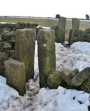 ss a farm road through wall stiles, and keep going uphill in the same direction through two more fields, with wall stiles. At the top of the second field an extensive view opens out over Netherthong, with Wooldale on the hill to the left stretching over to New Mill.
From here the track continues in the same direction, then slightly to the right, downhill towards Netherthong. Leaving this field the track is now enclosed on both sides (and can be very muddy); shortly after it takes a 90o left turn and descends more steeply (take great care). On the left is an orchard, whose products you can sample when, at the bottom of the hill, you reach the Cider Press Cafe (open Wednesday to Friday until 4pm, and to 6 pm at weekends; dogs welcome). Alternatively, a little further on is the Cricketers Arms.
Turn right onto a track immediately after the Cricketers Arms. Where the track becomes St Mary’s Lane, just after The Old Chapel of 1767 on the left, a public footpath sign points down some steps which lead over a little bridge (over Dean Brook) and left up to a road. Turn sharp right onto this road and almost immediately left to walk up a cobbled road, which then joins another road (Outlane).
Netherthong is an attractive village with many interesting buildings in the local vernacular style, including many weavers’ cottages with long rows of mullioned windows on the top floor (some with three-storeys). As you walk up through the village also look out for the Methodist Free Church of 1872, no 15 Outlane with a fine Venetian window, and the attractive cottages on St Ann’s Square at the top of the hill on the right.
At the top of the hill you reach a main road; turn right and continue for nearly 200 yards. Then look for no 24; and on the opposite side of the road, at the left-hand end of a low stone wall, you will find a guide stone.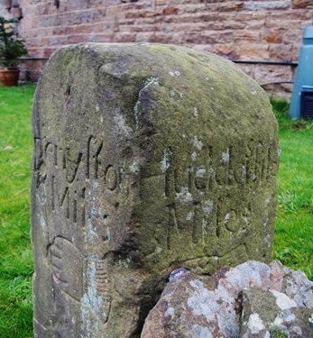
Guide stones or stoops (as they are known locally) were erected in the early 18th century by local township surveyors on the instructions of the county justices: they were particularly to be set up at cross-roads “upon large moors and commons where intelligence is difficult to be had” – as instructions of 1733 put it.
This particular stone is not in its original location, having been moved in recent years (though it is probably safer where it is now). It was shown on Ordnance Survey maps until recently as a milestone on Bradshaw Road (off the road between Wilshaw and Netherthong), where it had been used as a gatepost. This was not, however, its original site, which was probably at the crossroads higher up Bradshaw Road – about 1½ miles from its present location.
It belongs to a series of stones (there are two more in Meltham) on the Maythorn Way, an ancient track linking Marsden with Penistone. This stone shows directions to Marsden (5 miles), Penyston (8 miles) and Huddersfild (sic) (5 miles), with pointing hands for the last two destinations. Note that mileages are not current statute miles but earlier traditional miles which were longer (and varied across the country).
Now return back the way you came, but continuing along Town Gate, past a Londis mini-market, to the Parish Church (All Saints, 1830). Here the main road turns right downhill as New Road, but go straight ahead on the “old road” which leads down to Thongsbridge, an original crossing of the River Holme. This becomes School Street. Immediately after the school (and before the Pre-school/ Playgroup) take a path on the left which leads down to a road.
Turn right and follow the road downhill, past new houses built on the site of Deanhouse Mills, an old wall of which can occasio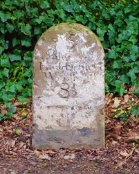 nally be seen on the left. You will reach a T-junction at Lower Hagg.
You have now met the “old turnpike” again. To the right it descends gently to Thongsbridge, from where it initially crossed the river and went up Berry Bank Lane to enter Holmfirth from the direction of New Mill. The direct road into Holmfirth was constructed in 1771/2.
Turn left and go uphill a little way, around two bends, to the wood (Hagg Wood); a track on your right (with a sign pointing to the studio of an artist, Natalia Dolgova) will take you along the side of the wood until it reaches the main A6024.
If you now turn right and walk along the road a little way you will see the next Huddersfield/ Woodhead milestone (5 miles to Huddersfield). This is in a slightly better condition than the Huddersfield 4-mile stone seen earlier on the walk.
Or if you turn left you come after about 250 yards to a nice boundary stone marking a boundary between Honley 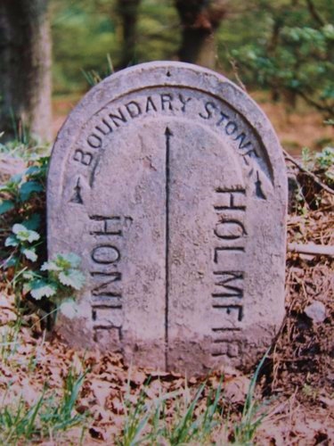 and Holmfirth. This was originally the Netherthong/Honley boundary, but as Netherthong was incorporated into Holmfirth in 1912 this stone must date from around that time. (NB: this photo was taken some years ago: there is not as much visible now).
Whichever of the above options you take (if any) return to where you joined the main road, cross it, and take the lane which continues down to a campsite.
This lane, from where you left the old turnpike until you reach the A616, is called Lancaster Lane. It is named after the textile mill of James Lancaster & Sons, cloth finishers, which stood on the site of the present campsite until 1975.
Just before the campsite take a track to the left (there is a no-through-road sign), and follow this. It turns right to cross the River Holme and then climbs gently back to the A616. Continue along this for the short distance back to Brockholes where you began, crossing the road at the pedestrian crossing.
Further information
If you would like to know more about any of the features of this walk you may find the following books interesting. Some can still be bought at the Tourist Information Centre in Holmfirth; others will be available in local libraries (while they exist).
W B Crump: Huddersfield highways down the ages (Tolson Museum, 1949)
Allan Place: Routes of our valley’s past (Holme Valley Civic Society, 1999)
Ken Kaye and David Wyles: Discovering beautiful Brockholes: six circular walks (Brockholes Village Trust, 2012). Walk no 6 in this booklet is, coincidentally, virtually the same as this walk, but concentrates on different items of interest.
Michael Day: Wool and worsit: a history of textiles in the Holme Valley (Laverock Publishing, 2013)
Ray Masson: Hope Bank: Honley’s pleasure grounds and gardens (Honley Civic Society, 3rd ed 2013)
And, of course, the Yorkshire Milestones website: www.yorkshire-milestones.co.uk
RWH/April 2015